by admin
Share
by admin
Share

For decades, Malawi’s Tundulu carbonatite complex has been known primarily through one hill and two historical drilling campaigns. The rest of the ring structure, comprising four additional topographic highs interpreted as sister carbonatite centres, has sat essentially untested beneath tropical vegetation and weathered overburden.
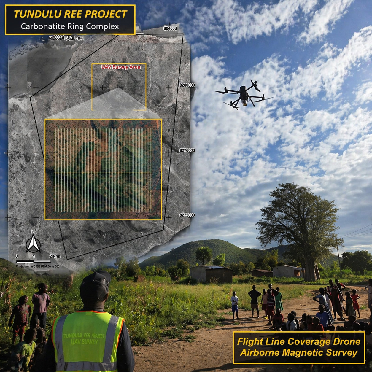 AuKing Mining’s just-completed airborne survey is the first real step in unlocking Tundulu.
Chilwa Alkaline Province
Tundulu sits within Malawi’s Chilwa Alkaline Province, the same geological neighbourhood that hosts Songwe Hill and Kangankunde, two deposits that have put Malawi firmly on the global rare earth map.
Carbonatites of this kind are among the most important primary sources of rare earth elements on Earth. They host the world’s supply of critical magnet metals: neodymium and praseodymium for permanent magnets, along with the “heavies” such as dysprosium and terbium, which give those magnets their temperature performance in electric vehicles, wind turbines, and defence electronics.
What makes Tundulu particularly compelling is that it is not a single plug but a 5 km-diameter ring complex. In carbonatite systems, rings, cone sheets, and nested intrusions generate multiple opportunities for mineralisation, and late-stage fluid pathways, where the most enriched REE phases tend to precipitate, hug exactly those structural features.
Technology: UAV Mounted Magnetic/LiDAR
Running a UAV-mounted magnetic and LiDAR platform across a project like Tundulu brings three capabilities that traditional fixed-wing surveys simply cannot match at this scale.
- Resolution: Flying magnetic lines 50 metres apart at just 45 metres above the ground produces data sharp enough to pick out individual dykes and narrow intrusive contacts. These are features that are invisible at regional line spacings but crucial for hitting mineralisation.
- Topographic fidelity: LiDAR fires laser pulses through gaps in vegetation and reconstructs the bare-earth surface beneath. In a landscape where tropical bush obscures subtle scarps, circular drainage patterns, and fracture corridors, this is transformative. Faults and joints that controlled the emplacement of carbonatite dykes, and later the flow of mineralising fluids, often reveal themselves only in centimetre-scale topography.
- Speed and sensitivity: Roughly 330 line-kilometres across a rugged volcanic complex in ten days, with minimal surface disturbance and direct day-to-day engagement with surrounding villages, is a footprint that was not available to earlier operators working the same geology on the ground.
Identifying Heavy Rare Earths
One of the most valuable aspects of what an integrated magnetic-LiDAR survey does is help geologists look for the right magnetic signature, not necessarily the brightest one.
The sövite cores of carbonatites are magnetite-rich and stand out boldly on a magnetic image, but they are frequently not where the highest REE grades sit. The prize is usually in:
Late-stage ferrocarbonatite and REE-carbonatite dykes, which cut through earlier intrusive phases and concentrate monazite, bastnäsite, and synchysite. The latter two are key hosts of heavy rare earths. These dykes appear as more subtle magnetic features tucked inside or along the margins of the main complex, visible only when the data are processed through derivatives like tilt and analytic signal.
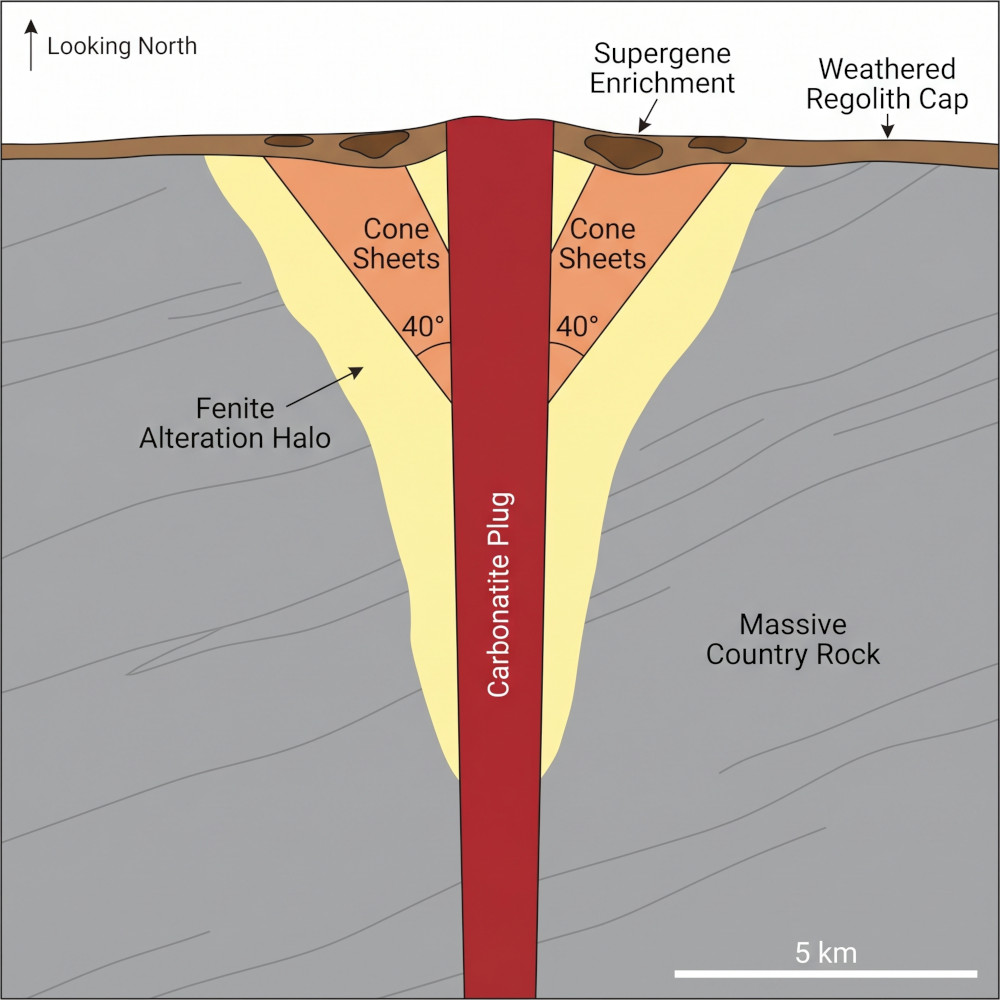
Schematic cross-section of a typical carbonatite intrusive system, showing the central plug, inward-dipping cone sheets, fenite alteration halo, and weathered regolith cap where supergene REE enrichment can occur. Not to scale; illustrative only.
Apatite-rich phoscorites and apatite carbonatites, historically the focus at Nathace Hill. Apatite routinely carries REE in solid solution and is accompanied by characteristic magnetite textures that high-resolution magnetics can resolve in three dimensions.
Fenitised aureoles, the altered halo where carbonatite-derived fluids reacted with surrounding rock. Fenites at analogous deposits, including nearby Songwe Hill, host economically meaningful REE mineralisation in their own right.
Structural intersections, especially where ring fractures meet radial dykes. These are the natural plumbing of a carbonatite system, and they tend to show up as crisp lineaments in LiDAR hillshades laid over magnetic interpretations.
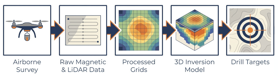
By producing 3D magnetic inversions alongside a detailed structural framework, AuKing’s geophysical team will be able to rank targets against multiple independent lines of evidence at the same time. That is a fundamentally more efficient way to prioritise drilling than using surface geology alone.
Weathering
LiDAR has another capability highly relevant to Tundulu. Carbonatites weather aggressively, and their weathered profiles can dramatically concentrate REE through the supergene processes. This is the same mechanism that transformed Mount Weld in Western Australia into a globally significant deposit. Slope, curvature, and drainage analyses derived from a high-resolution LiDAR digital elevation model help predict where weathering blankets are thickest and least disturbed. That information can meaningfully upgrade a drill target.
Historical exploration
Previous work at Tundulu focused almost entirely on Nathace Hill, with drilling aimed at its apatite-monazite potential. That is a narrow slice of what is now recognised as a very large system. With four additional interpreted carbonatite centres (Makhanga, Namuka, Ichigwakalu, and Tundulu Hill itself) now sitting under modern, high-resolution geophysical coverage, the project steps up from a single-target story to a multi-centre discovery platform.
The airborne survey is essentially a cost-effective way to test each of those hills for carbonatite character, structural favourability, and weathering profile before engaging the drill rig.
Imminent Drilling
With data processing underway and the first results due in a matter of days (levelled magnetics, 3D inversions, derived grids, and bare-earth LiDAR terrain models), drill targeting can move to interpretation.
Contractor discussions are already live, approvals are advancing in parallel, and a May start for drilling is on the table.
Tundulu has been known for a long time. What has changed is the ability to actually see it.
For the first time, the full ring complex is about to come into focus, and with it, a genuine opportunity to define the scale of what the Chilwa Province is still hiding.